Projects
Framework Service Contract for Copernicus Emergency Management Service / Risk and Recovery Mapping, 2015, EC-DG JRC
The European service "Copernicus EMS - Mapping" and more specifically the "Risk and Recovery Mapping (RRM)" part addresses the needs of entities involved with the management of natural disasters and humanitarian crises, through providing timely and accurate geospatial data, which are produced using satellite imagery. Existing geospatial data and / or field data are also integrated. The resulting information is delivered in the form of printable maps and / or GIS files (vector - raster) for further analysis.
The RRM products refere to the support of measures / activities, which are linked to prevention, preparedness, risk reduction and mitigation and rehabilitation. The products are distinguished in three general categories: (a) Reference Maps (b) Pre-disaster & (c) Post-disaster Situation Maps.
Our company, as leader of the consortium "Geoapikonisis AEMGE - National Observatory of Athens (Greece) - CIMA Research Foundation (Italy) & TRE Altamira Information (Spain)", is a contractor under the RRM module and has successfully implemented the following Services' Requests/ Activations:
- EMSN-18 AZORES || Multiple natural hazard risk assessment - Planning and Recovery
- EMSN-20 MADEIRA || Multiple natural hazard risk assessment - Planning and Recovery
- EMSN-21 AUSTRIA || Earthquake risk assessment Austria - Planning and Recovery
- EMSN-22 BULGARIA || Post-disaster analysis, damage assessment, recovery and rehabilitation planning and monitoring, flood risk assessment, disaster preparedness and response mechanisms
- EMSN-25 GREECE || Forest fire damage assessment - Planning and Recovery
- EMSN-26 SPAIN || Post-disaster assessment of toxic cloud dispersion after an industrial accident
- EMSN-30 UKRAINE || Ground deformation mapping and monitoring by satellite based multi-temporal DInSAR technique
- EMSN-31 MADEIRA || Forest fire damage assessment and landslide risk
Digital Services for Single Subsidy through the updated Land Parcel Identification System, 2014
Update of the Land Parcel Identification System (LPIS), which is common to the single payment application, as it is required by the relevant European legislation towards providing services of electronic submission of the single payment applications by the farmers; e -YpAAT portal (webGIS). The works consist in redesigning (vectorization and land use/cover assignment) the (reference) ilots and subilots through photo interpretation of VHR satellite data in GIS-RDBMS environment.
Study Area: Greek territory.
Integrated Information Management System of Cultural and Sports Facilities of Ziros, 2014, Municipal Authority
Design and implementation of an online Geographic Information System, which integrates information and data cultural and sports events and infrastructure and includes:
1. Appropriately documented Points of cultural, sports and touristic interest of the municipality; descriptions, equipment, business hours, photos, etc.)
2. Interaction with citizens (reservations of 5x5, basketball, etc., courts, etc.)
3. Appropriately documented Routes of Scenic and/or historical interest: Dynamic maps enriched with multimedia content in selected locations - Virtual tour,
4. Organized multimedia content (images, videos) for the tourist and cultural promotion of the Municipality
Web: http://gis.dimoszirou.gr/
EOEUROPA - ANNEX H: Urban Development, 2012, ESA
The project aims to develop, demonstrate and evaluate efficiency of the information generated through using/ processing satellite data for (a) analysis of the current situation in the first place (Appraisal phase), (b) monitoring the evolution of ongoing works (Monitoring phase) and (c) the final assessment (Evaluation phase) following the implementation of programs that are financed through long-term loans from the European Investment Bank (EIB).
The services were developed in the context of the program "Urban Development of the region "Eleonas" (Athens) and aim to effectively analyze the situation / evolution of the region in the period 1995-2011.
Development of services and Products through exploiting Earth Observation (EO) data that provide accurate, objective and comparable information, useful for analyzing the current situation (Appraisal phase) and changes and to assess the dynamics of the area.
Reference years: 1995, 2000, 2007 & 2011
Satellite data: KVR-1000, QuickBird, WorldView-1 & 2
Projects for the establishment of Forest Maps within fire affected and protected areas of the Country (Code Δ4), 2012
Creation of a geospatial database referring to land cover (forest, pastures and other use / cover). The areas’ delimitation and classification was based on very high resolution RGB and B/W orthophotos.
Changes detection (1945/2007) and integration of limits of Administrative Acts were also involved in the approach towards establishing forest maps at the Evia Prefecture (Hellas).
KT03: Second Phase Cadastral Study for the creation of National Cadastre in the municipalities of Agia Barbara, Egaleo and Peristeri (Attica Prefecture), 2012, NCMA SA
In the context of the project realization cadastral services were implemented and support services were provided.
Cadastral works: Creation of the first / draft cadastral base-map, Collection, Processing and Control of the beneficiaries' declarations & objections, Creation and Maintenance of the Cadastral Data Base, Public Display, etc.
Support Tasks: Citizens' Reception and technical support, Collection, Processing and Control of requests, etc.
Region of Ionian Islands - Studying Interventions towards Improving Safety on the Road Network of the Lefkada Prefecture, 2012, Egnatia Odos SA
Creation of a Geo-Database with three-dimensional (3D) video data of the Road Network for Lefkada Island (Greece).
- 3D Mobile Mapping surveying (3DMMS) of the Roads' axis to define geometry, photographic documentation of characteristic Points of Interest
- Digitization / classification of the roads' pavement damages and roads characteristics
- Identification of (safety related) problems / Specification of the necessary interventions (short and medium terms)
- Diagrams edition (general horizontal alignment roads' sections, Detail Plans for Short Term Intervention, etc.)
3D Geo-Referenced Mapping of Road network, 2011, DLS, Cyprus
Creation of a Geo-Database that integrates the 3D imagery of the Road Network, for the city and the suburbs of Nicosia.
- 3D Mobile Mapping Services (3DMMS): Collection of three-dimensional georeferenced (high precision) image frames, of the road network of the larger Nicosia area (32 municipalities / communities. Measurement of control points coordinates. Data processing and production of 3D files (with proper geo-referencing - accuracy and through erasing personal data)
- Creation of Metadata
- Supply of Hardware and Basic software
- Design, Development, Installation & Maintenance of the Database
- Design, Development, Installation & Maintenance of the Applications for Management and processing of the three-dimensional Imagery
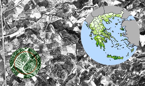
Mapping Seismic Vulnerability and Risk of Cities (Massive), 2010, EC-DG ENV
Design and development of a Crisis Support System towards an optimized Crisis Management, referring to earthquakes events within urban environments.
The products can be used for timely planning of interventions (building aid, openings / configurations roads, setting citizens’ assembly points, etc.) and mitigation of impacts.
Project pilot areas:
- Attica region (Greece)
- L' Aquila (Italy)
Consortium:
- National Observatory of Athens
- Institute for Astronomy, Astrophysics, Space Applications and Remote Sensing (Consortium Leader)
- Institute of Geodynamics
- Geoapeikonisis SAPGE
- National Technical University of Athens
- Planetek Italia
Users: Civil Protection units of EU Member States
http://massive.eu-project-sites.com/
Development of a Geographic Information System & Applications of the National Roads Registry - Technical Support, 2009, MEPPPW
Design and development of an integrated information system for the integrated management of (spatial and attribute) data of the national and provincial road network of the country.
System and Applications (web and desktop GIS) Development; operation of the National Register of Road Network, management of road network and roadside areas data, of road safety information, national road network maintenance data and traffic volumes.
Road Network of Cyprus, 2009, CYSTAT
Generation of the Cyprus Road Network Geo-Database. The whole of the roads of the non-occupied part of Cyprus (road types, names, numbering, etc.). Digitization of vector data through digitizing Very High Resolution satellite data. Ground surveying assisted by an (own) developed Mobile GPS-GIS platform.
Edition of eco-touristic maps of the Prespa area, 2008, S.P.P
Design and realization of Data Base and digital maps with eco-touristic information. Supply and processing of satellite images (very high resolution, IKONOS, 1m, 2006 acquisition). Delimitation and classification of land cover / land use polygons, digitization of linear and point entities through photo interpretation of satellite images.
Field surveying; Verification of land cover / land use and measurement of control points coordinates. Integration of Points of Special Interest (e.g Resting locations, Information Center, Meadows with Daffodils, etc.)
Establishment of the National (Greece) historical orthophotos data base, 2008, NCMA SA
Generation of, large scale (1: 5000) digital orthophotos and DTM, through digital photogrammetric processing of large scale (1:30.000) historical aerial imagery (1945 and 1960 acquisition years).
Coverage: the entire Greek territory.
Main use: Forest maps production towards establishing the National Cadastre.
GEOLAND2 - towards an operational GMES Land Monitoring Core Service, 2008, EC / REA / S2
Development of Products & Services in the frame of the project’s “Forest Task”. Monitoring and Management of the Environment at International, Regional and Local level, according to the applicable regulatory and legal framework. Satellite (multi temporal / multi resolution) and other (DEM, forest inventory data, etc) data usage, with the aim of monitoring forest ecosystems of southern Europe.
Design Development and Implementation of Core Mapping (CMS) - Core Information Services (CIS) and generation of relative Very High Resolution (VHR) layers:
- forest - non forest mask
- forest type map
- forest density map
- forest mask changes - forest type changes & forest density changes
- environmental indicators
Pilot study areas:
- Portugal - Spain
- Malta
- Bulgaria - Greece
- Cyprus
http://www.copernicus.eu/projects/geoland2
Integrated Geographic Information System of Agrinion, 2008, Municipal Authority
Design and Development of an integrated information System dealing with operational requirements for geospatial information management and exchange within the municipal services.
Software supply: Geographic Information System (GIS), online geographic data distribution software (Web GIS) & Database (RDBMS).
Development of Subsystems addressing Management of Assets & Services; Urban Settings, Building Permits, Electro-lighting Network, Road Network, Cleaning Services Network, Inter-municipal Police Network, Communal Services, Municipal space Licensing Operations, Water Supply - Sewage Network.
Creation of a Digital Database of Active Titles of Land Registries of Urban Centres and Support Services, ET-02 & ET-04, 2007, NCMA SA
Study for the production of a digital database of Active Land Registry Titles in urban centers and support services.
Contracts:
- ET-02 - Municipalities of Agia Barbara, Egaleo, Peristeri, Piraeus and the Local District Samian of the Municipality of Vathi of Samos.
- ET-04 - Municipalities of Agioi Anargyroi, Ano Liosia, Aspropyrgos, Acharnes, Zefiri, Thrakomakedones, Ilion, Kamatero, Mandra, Petroupoli, Filis, Haidari and for the Community of Kryoneri of Attica.
GSE MARCOAST, STAGE 2 - SCALING-UP CONSOLIDATED GMES SERVICES, 2007, ESA-ESRIN
The GSE MarCoast (Marine and Coastal Environment Information Services) refers to two application areas: (a) Monitoring of Oil Spills and (b) Evaluation of Water Quality in coastal areas.
This project complements the information provided by the individual actions, since the information about oil spills in conjunction with SAR images "feed" the system (under development) by seeking the support of the operations for identifying the responsible(s) for a pollution event.
The system uses (real time) data for the dynamic monitoring of maritime traffic (AIS and VTMIS) in conjunction with space observations (SAR / ERS-2, ENVISAT) and information from maritime surveillance operations. To meet specific operational needs of the Hellenic Coast Guard, the design and development of the system was based on ECDIS (Electronic Chart Display and Information System). The operation of the system supports improved knowledge on shipping and allows for timely decisions for: a) locating suspect for illegal entry vessels, b) identification of ships which may assist rescue operations & c) detecting ships suspect for environmental damage (water pollution).
http://www.copernicus.eu/projects/marcoast
Integrated Geographic Information System of Orestiada, 2007, Municipal Authority
Design and Development of an integrated information System dealing with operational requirements for geospatial information management and exchange within the municipal services.
Software supply: Geographic Information System (GIS), online geographic data distribution software (Web GIS) & Database (RDBMS).
Development of Subsystems addressing Management of Assets & Services; Urban Settings, Building Permits, Electro-lighting Network, Road Network, Cleaning Services Network, Inter-municipal Police Network, Communal Services, Municipal space Licensing Operations, Water Supply - Sewage Network.
Integrated System for Optimal Management of Environmental Parameters of Sensitive Areas, 2007, Arcadia Prefectural Authority
Design and Development of an integrated information System dealing with operational requirements for the management of environmental conformity licensing and the monitoring of environmental parameters, in order to reorganize the process of issuing the relative (environmental conformity) permits for the installation and operation of economic activities within the prefecture administrative area. The system optimizes environmental protection efficiency through adequate integration of the legal framework provisions while, at the same time, it drastically enhances the reliability of the daily operations of the relative Prefectural Services through establishing transparent procedures based upon systematically updated information.
Development of Subsystems addressing Management of Assets & Services:
- Background / Basic Data Management
- Portfolio of Application (reviews, status update, etc.)
- Legal Framework Management
- On-line (internet) information access and download
PRODUCTION OF LARGE SCALE ROAD NETWORK DATA BASE OF THE ATHENS & THESSALONIKI URBAN AGGLOMERATIONS AND THE NATIONAL ROAD NETWORK. DESIGN - DEVELOPMENT & DATA BASE MANAGEMENT, 2007, HIT
Update of road network data (vector, attribute) at a cartographic scale of 1: 5,000.
Digitization roads axes and limits; usage of satellite images (very high spatial resolution/1m, IKONOS, 2006 acquisition), field data collection and field surveying work through kinematic satellite tracking operations. Management - Processing of the alphanumeric data (road category, numbering, directions, etc.) of the information layers that were generated.
Digital Cartography Support of Farmers Associations (IACS), 2006-07
The enhanced and strict requirements adopted for granting the subsidies to the farmers relate to correct location and delimitation of the declared (for subsidies) parcels. The vast majority of the farmers associations in Greece had to deal with inaccurate and problematic parcels identification and delimitation (previous years campaigns). The lack of a cadastral infrastructure and the changing strategies of the farmers as far as it concerns their cultivations (parcels location, cultivated crops, etc), render the localization exercise of parcels difficult. The collection of compliant data becomes more complex if it relies on analogical data (orthophotos, ilots, etc.).
To optimize the process of the submission of the declarations and to obtain a “correct" and complete data set of the declared parcels, certain Farmers' Associations adopted the digital approach for the collection of the declarations. To facilitate them, GEOAPIKONISIS designed, developed and implemented the necessary SW infrastructure.
Land & Sea Integrated Monitoring for European Security (LIMES), 2006, EC-DG XII
Development of a real-time system for surveillance and protection of sea borders and individual ships sailing in open sea and dangerous areas, through combining satellite remote sensing technology and terrestrial maritime traffic monitoring systems (AIS, VTS, VTMIS).
ECDIS (Electronic Chart Display and Information Systems) was used for the design and development of the system.
http://www.copernicus.eu/projects/limes
LUCAS studies 2006 || LOT1 - Landscape Classification, 2006, EUROSTAT
Design and Development of a Geographic Information System Development for systematic monitoring of landscape changes, through using geo-spatial data and landscape assessment indicators (landscape indicators) for the entire European continent. Implementation of innovative methods and optimized use of LUCAS data (orthophotos, field images, etc.).The project objective being to further develop a set of meaningful landscape indicators across Europe, through deploying innovative state of the art methods for optimizing the usage of the whole of the data of the LUCAS campaigns (orthophotos, landscape photos, etc). The project focused in exploiting the LUCAS data set, which covers (with some exceptions) the whole of the European territory and refers to information that is collected (annually) with common specifications and quality level (objectivity and precision of the information).
A high-level expert scientific group on landscape characterization has been set up to provide advice and guidance to the work as well as their opinion on the project results and findings. The outcome of an in depth analysis of the state of the art and the available data sets has guided the project orientation and developments. The analysis has pointed out the strengths and the weaknesses of the existing data sets towards establishing a systematic monitoring scheme of the European landscape and in this context the design of the indicators and the necessary implementations accounted for the data specificity as well as for future enhancements in their quality. The landscape classification accounted for the LANMAP2 categorization of the European landscapes and in this frame the access (for internal use only) to the LANMAP2 data set was secured for the consortium partners and for EUROSTAT. The project implementation and system performance demonstration was based on the data of a number of sample sites (11 areas (NUTS Level 3) of the following Member States: Spain (1), Italy (2), France (2), Hungary (1), Luxembourg (1), Poland (2), Czech Republic (1) and Slovenia (1).
A performant Software Quality Assurance Plan was also developed and applied to set up the SW specifications and to monitor the evolution and performance at the various stages of the development.
A Surveillance System for Assessing and Monitoring Desertification (Desurvey), 2005, EC-DG XII
In spite of the relevance of diagnosis to help the success of desertification treatment, there is a lack of standardised procedures to perform it at operational scales. DESURVEY contributes to fill this gap by complementing assessment of desertification status with early warning and vulnerability evaluation of the involved land use systems. To this purpose the interactive effects of climatic and human drivers of desertification are taken into account in a dynamic way. The project goal is to deliver a compact set of integrated procedures, with application and tutorial examples at the EU and national scales. and other desertification threatened areas of UNCCD regional Annexes.
GEOAPIKONISIS contributes in assessing the eco systems dynamics through a multi temporal land /cover mapping in specified 10 years periods.
Consortium leader: Consejo Superior de Investigaciones Científicas / Estación Experimental de Zonas Aridas (EEZA)
http://www.copernicus.eu/projects/desurvey
EURORISK / PREVention, Information and Early Warning (PREVIEW), 2005, EC-DG XII
Development of new / enhanced information services for risk management at European scale, towards efficiently supporting European Civil Protection Units and relevant local or regional authorities. Optimized usage of the most advanced research and technology outcomes in Earth Observation.
Test site: Kefalonia island (Greece)
http://www.copernicus.eu/projects/preview
Digitization of 4500 Land Zone Plans, 2005, DLS, Cyprus
Production of a Spatial Database with the urban planning zones of the Republic of Cyprus. Supply and Installation of Hardware & software.
Controls with Remote Sensing towards applying the simplified payment scheme based on areas in the context of the IACS, 2005, CAPO-Cyprus
The project was carried out in the frame of the sample control activities carried out every year from the relevant administration bodies (in this case CAPO) to check upon fraud in the declarations (cultivated area, crop type) of farmers.
Usage of multi-temporal satellite images of high and very high spatial resolution in two control areas. Verification of compliance in implementing Good Agricultural Practices.
Digitization of the parcels declared in the frame of IACS 2003 & 2006, Hellas
The project has been realized for 10 prefectures at 2003 and another set of 15 prefectures at 2006.
The project contributes at creating and updating the Land Parcel Identification System (LPIS) in the context of IACS and through identifying and resolving location and delimitation issues of agricultural parcels
Farmers' declarations data were subject of digitization and processing; cross checking of the declared data (parcels cartographic unique identifier, parcel area, parcels geometry (overlaps, etc)) with the results of the digitization.
Following this, on the basis of the findings, the parcels are assigned a proper code, referring to the processing results; "problematic" or "errors free".
Update and printing of the ilots’ maps, where the correct parcels are displayed only.
GSE Forest Monitoring, 2003 & 2005, ESA
Multi-Temporal mapping / monitoring of forest cover and assessment of forest biomass changes for the needs of Forest Management Projects of the MRD&F and towards managing industrial emissions according to the requirements of the Kyoto Protocol. Financial Framework: Global Monitoring for Environment and Security Program (GMES) Service Element (GSE) of the European Space Agency (ESA).
During the first stage of GSE the consortium has worked in parallel with the respective core user groups to consolidate the service-portfolios. GEOAPIKONISIS has developed a service portfolio designed to address, among other, the Greek Core users’ need for forest areas monitoring in the frame of the UNFCC and its Kyoto Protocol reporting framework.
During this second stage the GSE FM consortium has worked with the aim to expand the geographic but also the applicability and performance of the consolidated (during Stage 1) services.
The services are primarily based on EO data sources, but make best use of in-situ monitoring data. The services have consistently meet levels of quality, as required by end-users, and adapted responsively to evolving (more demanding) user needs.
The company developed and applied the validation protocol and performed quality audits to the whole of the services that were developed.
Study areas:
- Portugal - Spain
- Bulgaria
- Greece
http://www.copernicus.eu/projects/forest-monitoring
Intelligent Mobility Agent in Geographic Environments (IMAGE), 2002, HIT
Design, Development of the Project Data Base and GIS platform within the Data Management Action (Data management module) in Open Source platforms (JavaScript). Dynamic integration (XML) of data of External Content Providers (ECP) (eg commercial activities Data from professional associations - hotels, restaurants, etc.).
Project areas: Torino (IT), Tampere (FI)
http://cordis.europa.eu/project/rcn/59075_en.html
Methodological analysis of the results of the "LUCAS 2001" survey, 2002, EUROSTAT
The project involves the assessment of the effectiveness of the LUCAS survey methodology and organizational approach, following the experience of implementation in 2001, as well as the specification of alternative / optimized approaches. In this context, an analysis of the basic technical specifications was implemented (e.g. classification scheme, sampling plan, environmental information, assessment methods, implementation / organizational aspects). The statistical methods were also thoroughly examined and analyzed towards optimizing the survey results in relation to the sampling design, calculation of estimates, post-stratification etc.
The analysis allowed for appropriate recommendations for the project (annual surveys) future development and implementation and the amendment - among other - of relevant technical specifications and implementation guidelines.
Phare Multi-Country statistical co-operation || Sectoral projects on Statistics, LUCAS - PHARE, 2002, EUROSTAT
Technical Support to the Statistical Services of Slovenia, Estonia and Hungary, for the implementation of LUCAS (Land Use and Cover Area frame Survey) at a national level.
Development of a web Application in the context of the KATHENAS project developments, 2001,TREDIT SA
System of recording, evaluation and information provision regarding accessibility of urban environment by PSN - ΚΑTHENAS.
The web application developed under the program, enables Disabled people to find information relating to buildings of by public / municipal services as the characterization of their accessibility by disabled persons, transport lines, buildings photo, etc.
Application area: Sub set of the Athens Municipalities.
The application design and implementation was based on the "client" model. The (web) user can "download" locally both maps and executable code without special software requirements.
The development of the application involved the usage of the Jshape programming toolbox. Interaction with the user is assured through the JavaScript that communicates with the Java application, and is embedded in HTML pages.
Browser of the User: The application has been successfully tested with Internet Explorer and the Netscape Navigator / Communicator.
Photointerpretation of LANDSAT TM imagery to create a Land Use/Cover Map, for the Hellenic Statistical Authority, 2001, HEMCO
Small scale (1:100.000) Land Use / Land Cover mapping using satellite data for the Regions of Attica, Sterea Ellas & Euboea, Thessaly and Epirus.
Design and Implementation of a sampling scheme and definition of the ground data collection sample. Generation of the photo interpretation keys. Implementation and realization of comparative photo interpretation to assess limits and areas for 16 ‘generalized’ CLC categories.
Photo interpretation precision check.
Statistical evaluation of the precision of the photo interpretation on a Prefecture level. Map composition and printing of thematic maps and attribute tables (land cover/use areas) on a regional and prefectural level.
Set up of the Vineyards Register and the Geographic Information System on the Olive Oil Sector in Greece, 2001, MRD&F
Ground surveying and first / summary assessment of parcels limits.
Collection, integration, management and processing of raster, vector and alphanumeric information of 180.000 declarations (Vineyards and Olive plantations), 900.000 parcels and 25.000.000 olive trees.
Completeness, Correctness and Conformance control of the submitted declarations.
Verification of the declarations data; olive trees counting / detection on orthophotos.
Ground surveying for locating / verifying declarations data.
Maps edition and printing; large scale cadastral map (scale ≥ 1:5000).
Study Areas: Prefectures of Heraklion, Pieria, Viotia and Fthiotida.
Statistical Survey of Land Use / Cover, with the LUCAS methodology in Greece, 2001 & 2003, EUROSTAT
EUROSTAT Land Use Cover Area frame Statistical survey (LUCAS).
Ground surveying (5000 points) and documentation (landscape photos) of land use/ over and geomorphological characteristics within selected sampling units. Design and implementation of farmers interviews.
Digitization of the survey data. Statistical estimate of the land use/ cover areas, environmental parameters and crops yield.
Project area: Greek territory
Survey years: 2001 & 2003
Update of the Corine Land Cover data base for the year 2000, 2004, HEMCO
Production of the CORINE Land Cover (European Environment Agency) information for the Greek territory and the year 2000.
Delimitation of land use / cover and changes through photointerpretation of multi-temporal / multispectral satellite images for 1990 and 2000 and aerial ortho-photos. CORINE LAND COVER - 44 categories nomenclature; Land Use / Land Cover 2000 (CLC2000).
Control and assessment of the land use / cover 1990 and changes; Correction - Calibration of CLC90 reference layer (CLC1990, LCC1990-2000).
http://land.copernicus.eu/pan-european/corine-land-cover
Integration of ATLAS Databases, 1999, EC-JRC
Mapping of multi-temporal changes of Land Use / Land Cover & density (space / volume) of urban fabric in Attica, with the nomenclature Euro landscape - Moland (Level 4). Utilization of large-scale, aerial photographs (1960, 1972 & 1987) and satellite data of High & Very High spatial resolution (IRS-LISS III & IRS-P).
Reference years: 1972, 1987 and 1999.
Statistical estimation of the olive plantations areas in Greece. Field surveying and registration of the olive trees type (OLIAREA), 1999, EC-DG VI
Ground surveying of the number and type (productive, unproductive, new) of olive trees in 830 Secondary Sampling Units (SSU) of the OLISTAT project across the Country; measurement - identification of 35,000 trees. Assessment of individual populations of olive trees. Qualitative analysis of the results.
Digitization of the 1:50.000 map sheets issued by the Hellenic Military Army Geographic Service (HAGS), 1998
Digitization of (scanned) four-color transparencies of the relative map sheets. Information Layers: Road network, Hydrographic network, Contour Lines and Points Of Interest.
Area of Interest: West and Central Macedonia and Northern Thessaly.
Statistical estimation of the number of olive trees in Greece. Two-stages area frame sampling and counting of trees through photo-interpretation (OLISTAT), 1998, EC-DG VI
Aerial photos acquisition over the olives' production areas of the country, with a total extent of 55.000 km2.
Stratification of Greek territory through accounting the number of olive trees at Municipality level (statistical records). Design and implementation of a nation-wide sampling scheme.
Statistical selection: Primary (PSU) and Secondary (SSU) Sampling Units. Detection / digitization of 283.000 trees through photointerpretation. On the spot verification of the trees counting at 1.539 SSUs. Statistical estimates of the number (158 million) of trees at Country and Prefecture levels.
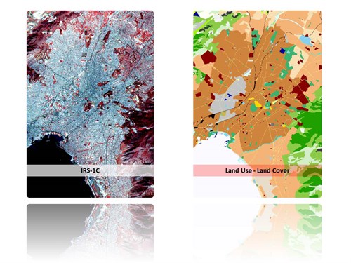
Urban Atlas data production for the greater Athens areas, 1998, EC-JRC
Land Use / Land Cover mapping of the urban area of the Attica basin according to the CLUSTERS nomenclature through appropriate processing of high and very high spatial resolution satellite data. The project was realized to fulfil EUROSTAT’s needs for establishing homogeneous and harmonized information of the urban areas across the European Union.
Design, Development and Implementation of an appropriate methodology for automatic and "objective" mapping of big urban agglomerations, following a common set of specifications.
Pan-sharpening of SPOT XS data with the Pan channel. Design and Implementation of a sampling scheme and generation of the photo interpretation keys.
Development of specific algorithms (texture), for the classification of the HR and VHR images.
Water resources management in the Mediterranean ISLAnds using satellite data (ISLA), 1998, EC-DG XII
Development of a water resources management system with integration of satellite (Landsat, SPOT & ERS-1) and auxiliary data and application of hydrogeological modelling in GIS environment for the Mediterranean islands.
Land use / land cover mapping using multi-temporal satellite data and estimation of the actual irrigation needs of the agricultural land at basin level. Integration of drilling data, surface runoff, precipitation, geological data, terrain model, vegetation index, rainfall and evapotranspiration estimates (METEOSAT data and data of ground meteorological stations), active rainfall estimates and estimate of the equivalent volume of snow melting water (RADAR data). Detection of submarine freshwater springs.
Pilot areas: Crete and Majorca islands.
CALamities Information System using Remote Sensing Techniques (CALIS), 1997, EC-DG XII
System development, through appropriate combination of satellite data processing techniques (calculation of agro meteorology parameters as surface temperature, vegetation index), telematics and GIS expertise (integration of alphanumeric, vector and raster data, agro meteorology data, crops specific data (phenology stages, critical weather conditions)), for the real time assessment of the impact of hazardous weather to the agriculture.
Web server implementation (24/7 availability), providing to the end users, relevant information for risk analysis and assessment, estimation of the risk severity and spatial distribution of the impact (yield loss).
Monitoring of the growing season and verification of catastrophic weather conditions; frost, drought, hail, extreme temperatures, etc. Assessment of the extent and severity of disasters using satellite data (NOAA, SPOT, LANDSAT). Severe weather conditions alerts & Impact Assessment (crop based disaster area and damage).
Publication: Information system for monitoring and evaluating meteorological disasters for agriculture, Medal D., Stakenborg J., Russell G., Biard F., Aifantopoulou D., Palacios M., Riglet J. P., Toulios L., Soler M. A., Masson J. L, Proceedings of the SPIE, Volume 3499, p. 307314 (1998).
http://www.ec-gis.org/Calamities information system
Aerial photography & orthophotos production under the olive & vineyard register in Greece, 1996 & 1999, MRD&F
Works for the Creation of the (1) Integrated Administration and Control System (IACS) and (2) Olive & Vineyard register.
Acquisition of aerial photos at 1:40.000 scale. Areas of Interest: (1) Regions of Macedonia and Thrace (20.915 km2) and (2) Regions of Sterea Ellas, Epirus, Ionian, Thessaly, Macedonia and Thrace (21.000 km2).
Scanning and digital processing of aerial photography (orientation, triangulation, collection of elevation data through stereo observations, etc.), production of Digital Terrain Model, orthophotos, etc.
Selection and measurement of control & check points' coordinates (GPS).
Edition and printing of orthophotos map sheets (1:5.000, EGSA 87).
Integration of aerial photography acquisition information (acquisition lines, photocentres, etc) and map sheets limits, administrative limits, etc.
Remote Sensing Controls of Arable Land and Forage Areas in the frame of IACS, Greece - 1994, 1996 & 1999, MRD&F
Area and cultivated crop verification of subsidized parcels, using multi-temporal satellite data of high and very high spatial resolution.
Year 1994 || Prefectures of Viotia, Trikala, Thessaloniki and Evros
Year 1996 || Prefectures of Viotia, Karditsa and Kilkis
Year 1999 || Prefecture of Kilkis
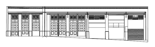
Terrestrial photogrammetry, Diagrams of Assets Facades
Compilation of digital diagrams of assets (buildings and monuments) facades in the context of maintenance, renovation, etc works. Photogrammetric Acquisition of ground photos. Measurement control / check points and features (lines, points) coordinates. Editing of diagrams.
 |
|
Archaeological site of Roman Agora and Hadrian's Library in Athens
|
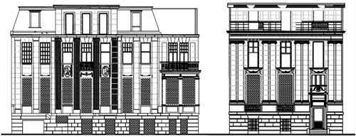 |
| Hellenic Embassy and Ambassador's residence in Berlin |

